")
25 Great Hiking Trails to Conquer This Summer
Lace up your hiking boots and get ready to explore. Ohio’s park systems and nature preserves have a wealth of trails to seek out this summer, from the rocky cliffs of Appalachia to the serenity of the Lake Erie shore.
This collection of hikes provides a snapshot of some of the trail experiences Ohio has to offer. They are a delightful mix of easy and difficult, hilly and flat, walks deep into the woods and ones along the Lake Erie shore, showcasing a small portion
of the adventures awaiting you across the state. This guide is meant to be an overview, and we suggest checking with any park system you plan to visit beforehand to learn about any park closures in effect and to confirm trail information. We hope you enjoy hitting the trails with our guide to 25 great hikes in our state.
NORTHEAST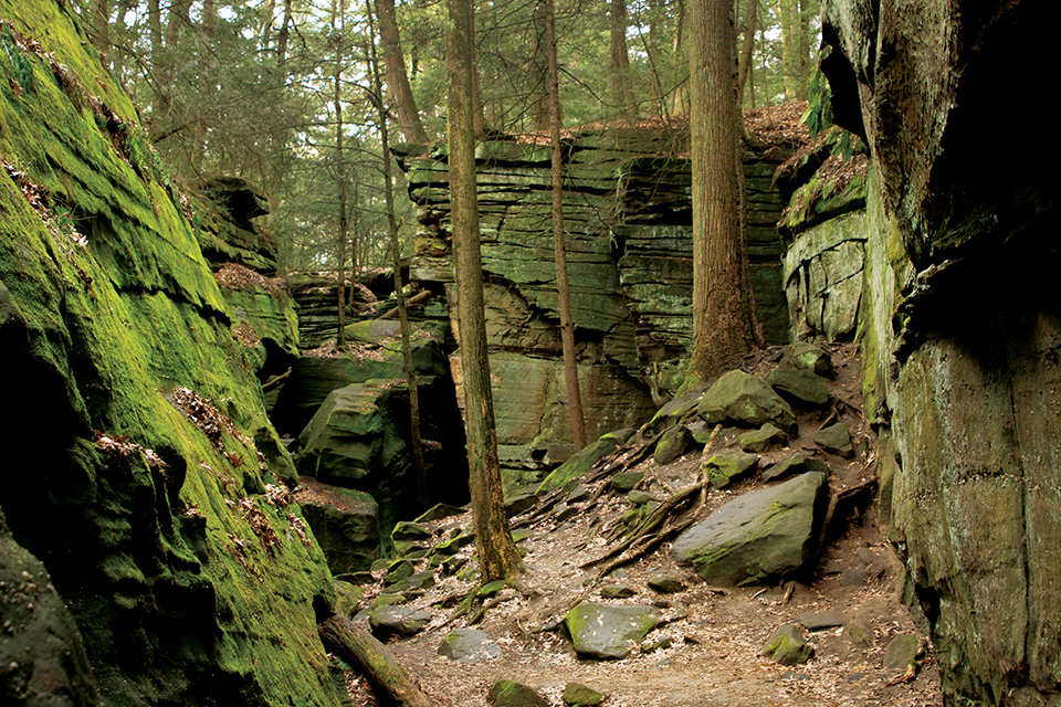
The Ledges Trail, Cuyahoga Valley National Park | 1.8 miles
This 1.8-mile loop through Ohio’s only National Park offers a moderately challenging hike along the base of these enormous rock formations.
Brandywine Gorge Trail, Cuyahoga Valley National Park | 1.5 miles
Brandywine Falls stands as one of the most popular destinations in Cuyahoga Valley National Park, and this loop hike shows
off the famous waterfall as well as the gorge it sits within. Start the hike on the boardwalk to take in views of the 60-foot falls and head counterclockwise, passing over the top of the falls and by the Brandywine Inn before descending through forest
to the creek below. A bridge crosses the creek at the far end of the route before the trail turns back toward the falls. After a climb up a long staircase, the pathway leads through the forest back to the trailhead parking lot. 8176 Brandywine Rd., Sagamore Hills 44067, nps.gov/cuva
Gorge Rim Loop Trail, Lake Metroparks’ Penitentiary Glen Reservation | 0.88 miles
This hike suits all ages and is popular with families. A full-acre natural play area can be found near the beginning of the trail and
is great for kids of all ages. The trail itself is pleasant in the summer as it is largely shaded and most of its surface is compacted gravel and completely flat. The trail passes through forest, and a set of steps lead down to a viewing area where
hikers can take in views of the gorge. The gorge itself has limited access because of its steep walls, exposed rock and fragile vegetation, although guided hikes with a park naturalist are periodically offered. 8668 Kirtland Chardon Rd., Kirtland 44094, lakemetroparks.com
Lyons Falls Trail, Mohican State Park | 2 miles
Visitors can start this loop hike at the Mohican Covered Bridge parking area. The beginning of the hike follows the Clear Fork Mohican River with some minor elevation changes
throughout. There is a small stream crossing, as well as stairs that lead to Big Lyons Falls. The waterfall measures 80 feet tall, has a recess cave behind it and is best viewed after a heavy rain. Otherwise, it is typically dry. From there, the trail
heads up a set of stairs and eventually meets Little Lyon Falls, which is a smaller waterfall but still worth stopping to see before returning to the parking area. Park Road, Perrysville 44864, parks.ohiodnr.gov
Adam Run Trail, Summit Metro Parks’ Hampton Hills Metro Park | 3.2 miles
This loop hike promises to get your heart pumping with elevation changes throughout that have placed it among the most demanding hikes in the
Summit Metro Parks system. Come prepared with sturdy shoes and plenty of drinking water. Along the trail, hikers encounter a few sets of stairs and minor stream crossings. Thanks to the concentration of oak, elm, sycamore and black walnut trees, visitors
can expect to hear many birds while hiking. The beginning and end of the hike pass by beautiful open fields and a meadow that contains milkwort, ironweed, Queen Anne’s lace, goldenrod and asters. 2925 Akron-Peninsula Rd., Akron 44313, summitmetroparks.org
NORTHWEST
Ottawa Wildlife Interpretive Trail, Ottawa National Wildlife Refuge
This 8-mile hike provides opportunities for birdwatching, wildlife spotting and scenic marsh views along the Lake Erie shoreline.
Water’s Edge Trail, East Harbor State Park | 2.1 miles
This trail offers an easy 2.1-mile walk that follows the sandy shore of Lake Erie. It offers views of Kelleys Island in the distance and parts of the Marblehead
Peninsula, as well as opportunities to see an abundance of wildlife. Eagles are often spotted flying by or perched in the tree branches above. Woodpeckers and migratory warblers flit from tree to tree, and water snakes and butterflies can be seen
during the warmer months. The trail starts at the edge of the parking lot and follows the waterfront to a boating channel where hikers can take a short loop past small sand dunes before heading back the way they came. 1169 N. Buck Rd., Lakeside Marblehead 43440,
parks.ohiodnr.gov
Fallen Timbers Northwest Territory Trail, Fallen Timbers Battlefield | 1.5 miles
Walking along the interpretive trail at Fallen Timbers Battlefield, it’s easy to imagine the landscape of over
200 years ago crowded with thousands of soldiers and Native Americans as they fought during the Battle of Fallen Timbers. The 1.5-mile loop winds through old-growth shagbark hickory and red oak forest, abutting meadows and thousands of new-growth
plantings. As you walk, stop to read the 17 plaques that trace the story of the battle that took place at this site. Less than a mile away, a monument at Fallen Timbers Battlefield Memorial Park marks where the site was believed to be until further
research was done in the 1990s. 4949 Jerome Rd., Maumee 43537, metroparkstoledo.com
Ferns and Lakes Trail, Oak Openings Preserve Metropark | 2.8 miles
It’s rare to find so many different landscapes within a 2.8-mile stretch, but Oak Openings’ Ferns and Lakes Trail offers just
that. Starting at the Mallard Lake parking area, take a short jaunt around either side of the lake to find the trailhead. Hiking counterclockwise, visitors first encounter lush marshland. (Here, be sure to keep an eye out for turtles, frogs and other
wildlife.) Following the trail, you pass into oak forest, then prairie, then planted pine forest. Transitions between each are shockingly distinct. The loop trail is mostly flat, with boardwalks in some of the wetter areas. Parts of this trail tend
to get muddy, so be sure to wear proper footwear. Mallard Lake Parking Area: 5402 Wilkins Rd., Whitehouse 43571, metroparkstoledo.com
North Shore Loop Trail, North Shore Alvar State Preserve | 1.3 miles
Hiking the 1.3-mile North Shore Loop Trail at Kelleys Island’s North Shore Alvar State Nature Preserve earns you a glimpse into one of Ohio’s
rarest ecosystems. Choose from the trailhead starting at the old quarry building or intersect the loop from the newly added link trail, located at the Glacial Grooves. Head counterclockwise for the quickest path to the main feature of this hike: the
alvar. The alvar’s unique characteristics — created by the glaciers that once scraped across its surface — give way to rare plant life. Visiting in summer, you can expect to see a variety of wildflowers, such as narrow-leaf summer
bluets, asters and goldenrod. Parking at Glacial Grooves: 739 Division St., Kelleys Island 43438, ohiodnr.gov
SOUTHEAST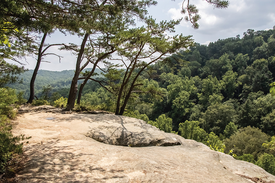
Conkles Hollow Rim Trail, Conkles Hollow State Nature Preserve
This 1.9-mile trek in the Hocking Hills features a short paved gorge trail for a family-friendly stroll and a rim hike that provides a scenic, cliffside adventure for more daring hikers.
Shadbush Trail, Salt Fork State Park | 3.8 miles (out and back)
Hikers can begin this out-and-back trek at either the Salt Fork State Park Campground Store parking area or the Salt Fork Lodge and Conference Center. (The
northern end of the path is about a quarter mile away from the lodge itself.) This path follows gently rolling terrain through hardwood forest and traces the shoreline of Salt Fork Lake for a portion of its length, offering hikers views of the water.
The trail has some mild climbs and descents but isn’t overly difficult. For those who want to tack on a few extra miles, head up Natural Resources Road 3 to connect with the nearby Pine Crest Loop and Morgan’s Knob Loop trails. Lodge: 11073 Natural Resources Rd. 3, Kimbolton 43749,
parks.ohiodnr.gov
White Pine and Vista Point Trails, Strouds Run State Park | 2.5 miles (combined)
These two trails form a Y, connecting the Strouds Run State Park campground and the White Pine Trailhead parking lot. Hiking the entirety of both
trails out and back offers some beautiful forest views and, most notably, a vista that overlooks Dow Lake in the distance. (A sign there notes that the vantage point is a good place to spot turkey vultures.) The campground side doesn’t allow
for parking unless you’ve paid to camp, so day hikers should make sure to park in the White Pine Trailhead parking lot along Strouds Run Road just past the lake on the right-hand side. White Pine Trailhead: Strouds Run Road, Athens 45701,
parks.ohiodnr.gov
Cantwell Cliffs Gorge and Rim Trails, Hocking Hills State Park | 1.3 miles (combined)
Tucked away along the northern edge of Hocking Hills State Park, Cantwell Cliffs features impressive rock formations. There are two
one-way trails (one goes into the gorge and the other traces its edge). Both are short and have the same starting point but also require a steep descent and the ability to navigate staircases. Start with the shorter Gorge Trail that treats hikers
to an enormous recess cave before heading into the gorge and back out. Make another trip right after, but this time, take a hard right after the initial descent on the stone staircase to follow the edge of the gorge and walk along the base of the
cliffs. 13640 St. Rte. 374, Rockbridge 43149, parks.ohiodnr.gov
South Loop of Selinde Roosenburg Memorial Backpacking Trail, Zaleski State Forest | 10.7 miles
Those looking for more of a challenge can opt for a day hike on the 10.7-mile south loop of Zaleski State Forest’s
Selinde Roosenburg Memorial Backpacking Trail in Vinton County. Set out from the Hope Furnace parking lot after checking out the remains of the old iron furnace there. Although there’s water and outhouses in two spots along the route, hikers
should be sure to pack extra water and food to fuel up for this trail’s steep hills. That means visitors are treated to sweeping views, along with cool rock formations, and an optional side trek to check out the supposedly haunted Moonville
Tunnel. 27331 St. Rte. 278, McArthur 46554, ohiodnr.gov
SOUTHWEST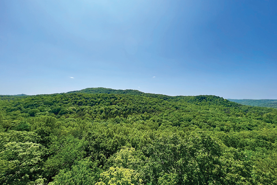
Buzzardroost Rock Trail, The Edge of Appalachia Preserve System
This 4.4-mile trail leads to a cliffside overlook with sweeping vistas, offering a hike that is moderately challenging while remaining kid-friendly.
Tailwaters Trail, East Fork State Park | 2.1 miles
While East Fork State Park in Clermont County has the most trails of any state park in Ohio, a great choice is the 2.1-mile Tailwaters Trail, located on the west side of the
lake near the U.S. Army Corps of Engineers property. It begins with a strenuous climb (and an elevation gain of 217 feet), leading to a fork in the road. It’s a “lollipop” trail, so hikers can either continue up the hill or go right
into the meadow that is known for its spring wildflowers. They then wind around before heading back on the same trail they started on. Parking available near Tailwater Shelter along Harsha Lake, Batavia 45103, parks.ohiodnr.gov
Junction Trail, California Woods Nature Preserve | 1 mile
Located within the city of Cincinnati along a bend in the Ohio River, the 151-acre California Woods Nature Preserve is easily accessible, offers engaging terrain
and transports visitors with true moments of solitude just a 10-mile drive from downtown. The preserve’s longest trek is Junction Trail, a mile-long loop that starts with a mellow climb up a hillside before weaving through the woods. If you’re
lucky, you might spot a pileated woodpecker, barn owl or great horned owl high in the sycamores. On the north side of the park, the trail runs over an old railroad bed. The preserve’s six other trails are a little more challenging and can be
added to create longer hikes. 5400 Kellogg Ave., Cincinnati 45230, cincinnati-oh.gov
Pine Forest Trail, Glen Helen Nature Preserve | 2.4 miles (out and back)
Hugh Taylor Birch gave the land today known as Glen Helen Nature Preserve to Antioch College in Yellow Springs in 1929 in memory of his daughter,
Helen Birch Bartlet. The private nature preserve now spans 1,125 acres and is the largest in the region. The 2.4-mile round-trip Pine Forest Trail begins at the parking lot and coincides with the popular Inman Trail as it crosses over Yellow Spring
Creek. It then traverses parts of the Upper Birch Creek Trail, the Lower Birch Creek Trail and the Sassafras Grove Trail as it leads to the preserve’s pine forest — a plantation of evergreens, with adjacent red oaks and tulip trees planted
in the 1930s. The preserve charges a parking fee. 405 Corry St., Yellow Springs 45387, glenhelen.org
Mud Lick Trail, Hueston Woods State Park | 1.8 miles
This loop hike has three spur access trails, allowing hikers to pick it up at the Hueston Woods Lodge, the state park’s cabins or a trailhead just off Main Loop
Road. The trail provides some views of Acton Lake near the lodge but mostly offers a serene, wooded trek through a mature beech-maple forest. The trail is mostly mellow, and part of it follows an unpaved country road that was last used in the 1940s.
Keep an eye out for wildflowers that bloom in early spring before the tree canopy above fills in to provide summertime shade. Lodge: 5021 Lodge Rd., College Corner 45003, parks.ohiodnr.gov
CENTRAL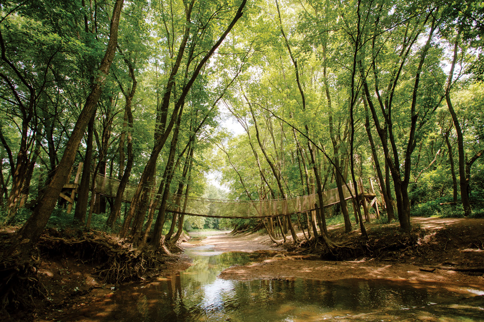
REI River Trail, Columbus & Franklin County Metro Parks’ Scioto Grove Metro Park
This
3.6-mile out-and-back trail along the Scioto River offers gentle terrain, backpacking sites and family-friendly features like a swinging bridge and archery courses.
Orange Loop and Blue Loop Trails, Christmas Rocks State Nature Preserve | 4.5 miles
Christmas Rocks State Nature Preserve once required hikers to obtain a permit to visit, and it remains a best-kept secret of sorts. The
trail starts at the gravel road just beyond the parking area adjacent to Lancaster’s Arney Run Park (where visitors can check out the Mink Hollow Covered Bridge) and heads uphill into the preserve. The hike consists of an Orange and Blue Loop,
with the former first leading hikers up to the top of the rock formation known as Jacob’s Ladder that stands 250 feet above Arney Run. The trail then descends and connects with the Blue Loop, which offers a shaded woodland walk before reconnecting
to the Orange Loop and leading hikers out the way they came. 2360 Meister Rd. SW, Lancaster 43130, ohiodnr.gov
Overlook Trail, Columbus & Franklin County Metro Parks’ Highbanks Metro Park | 2.3 miles
Access this trek behind the Highbanks Metro Park Nature Center by following the Dripping Rock Trail for
a tenth of a mile before taking a left onto the Overlook Trail. The trail continues 0.3 miles into the forest before turning into a loop. There is no wrong way to go, but hikers should be sure not to miss the spur at the far end that heads out past
historic earthworks and has its terminus at a 100-foot shale bluff that offers a look out over the Olentangy River. After enjoying the view, hikers can head back past the earthworks and take the other half of the loop to get back to the nature center.
9466 Columbus Pike, Lewis Center 43035, metroparks.net
Yellow Trail, Licking Park District’s Infirmary Mound Park | 1.95 miles
While this trail looks unassuming from its gravel entrance near Infirmary Mound Park’s picnic shelter No. 4, what unfolds
over the course of nearly 2 miles is worlds away from what its start suggests. The well-kept gravel trail leads into a scenic, natural surface hike filled with switchbacks through the foothills and even a hop across large rocks to get to the other
side of the path across a stream. After a slight uphill climb, the trail unfolds into a grassy opening where visitors can walk alongside Infirmary Mound. The mound is only a few feet tall and an interpretive sign at the site shares what is known about
the Indigenous people who built it. 4351 Lancaster Rd., Granville 43023, lickingparkdistrict.com
Butterfly Trail, Knox County Park District’s Honey Run Highlands | 1.5 miles
Though this Knox County Park District destination is well-known for its waterfall, there are other sights to enjoy across these 366 acres
located about 5 miles south of Danville. The Butterfly Trail is an easy trek, and the 1.5-mile loop follows a grassy trail, save for a jaunt through a pine tree grove that provides ample shade on summer days. Keep an eye out for the impressive anthills
that can be seen from the path and, of course, the butterflies for which the trail is named. Before visiting, hikers can check the Knox County Park District’s guide to the 58 butterflies found in the Honey Run Highlands to help identify them.
10816 Millersburg Rd., Howard 43028, knoxcountyparks.org
For more Ohio travel inspiration, sign up for our Ohio Magazine newsletters.
Ohio Magazine is available in a beautifully designed print issue that is published 7 times a year, along with Spring-Summer and Fall-Winter editions of LongWeekends magazine. Subscribe to Ohio Magazine and stay connected to the beauty, adventure and fun across our state.
Related Articles
")
Meet the Rare Beetle Ohio State Students Are Working to Save
The American burying beetle is making a comeback thanks to conservation efforts led by Ohio State University’s Bug Zoo and its partners. READ MORE >>
")
Summer in Dayton: Festivals, Live Music, Outdoors
This city offers plenty to experience, from open-air concerts to fun festivals to a quest to find artist Thomas Dambo’s famous trolls. READ MORE >>
")
Explore African Safari Wildlife Park in Port Clinton
With over 800 animals, this longtime northwest Ohio favorite invites families for a fun and photo-friendly experience. READ MORE >>
